

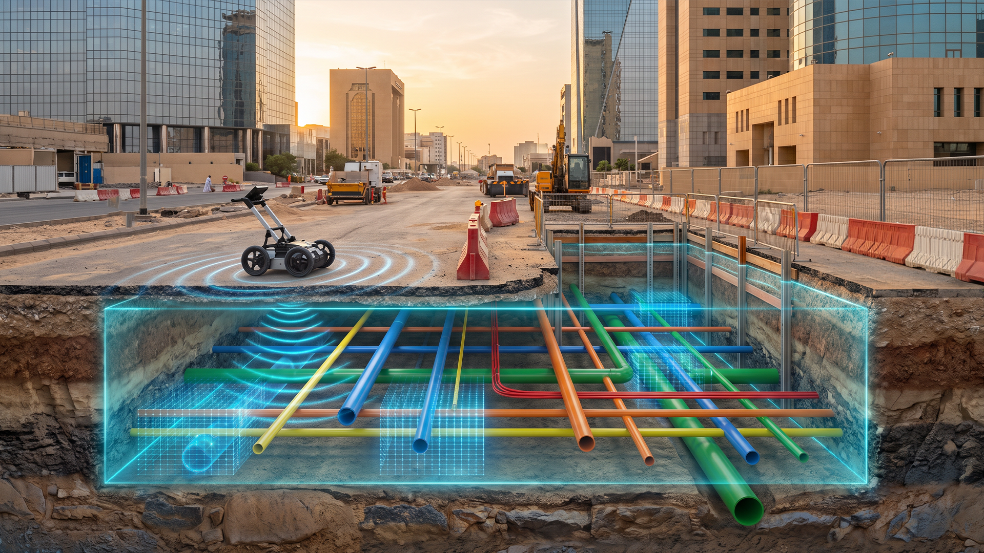
Underground utility networks—including water and wastewater pipelines, electrical and telecommunications cables, and gas lines—form the hidden backbone of every modern city. With rapid urban expansion and the growing number of infrastructure projects, accurately locating these utilities before any excavation or construction work has become an essential engineering and safety requirement.
Unplanned excavation without prior knowledge of buried utility locations can expose projects to significant risks, including service disruptions, environmental damage, substantial financial losses, and, in the worst cases, injuries or fatalities resulting from gas leaks or electrical shocks.
In this context, geophysical surveying technologies—particularly Ground Penetrating Radar (GPR) and Cable/Pipe Locators—have emerged as essential tools within a broader methodology known as Subsurface Utility Engineering (SUE). Al Qotr Engineering Consultancy is among the leading companies adopting and implementing this integrated approach across its projects in the Kingdom of Saudi Arabia, reflecting its commitment to the highest standards of accuracy and safety in infrastructure projects.
First: Understanding Subsurface Utility Engineering (SUE)
Subsurface Utility Engineering is an integrated methodology that combines geophysical surveying, geodetic surveying, and spatial data management using Geographic Information Systems (GIS) to accurately identify and document the locations and depths of buried utilities with defined levels of reliability and confidence.
The quality of utility information is commonly classified according to the American Society of Civil Engineers (ASCE) 38-22 standard into four quality levels:
- Quality Level D: Information derived from existing records and drawings without field verification.
- Quality Level C: Identification of surface-visible utility features and correlation with existing records.
- Quality Level B: Accurate horizontal identification of utility alignments using surface geophysical methods, such as GPR and cable locators.
- Quality Level A: Physical exposure of the utility through vacuum excavation to determine its horizontal and vertical position with centimeter-level accuracy.
Second: Ground Penetrating Radar (GPR)
How It Works
GPR operates by transmitting high-frequency electromagnetic pulses—typically ranging from 100 MHz to 2.6 GHz—into the ground. These waves are reflected whenever they encounter changes in the electrical properties of the subsurface medium, such as the contrast between soil and metallic or plastic pipes, or between soil and air-filled voids.
The system records the travel time and strength of the returned signal. By determining the wave propagation velocity through the medium, the approximate depth of the detected object can be calculated.
Key Advantages
- Detection of non-metallic utilities: GPR can detect utilities such as PVC pipes, concrete sewer lines, and fiber-optic cables that may not be detectable using conventional electromagnetic locating equipment.
- Generation of vertical subsurface profiles: GPR produces radargrams that display soil layers and buried objects, helping distinguish utilities from geological features such as voids or groundwater levels.
- Integration with GNSS: GPR data can be integrated with Global Navigation Satellite Systems (GNSS) to produce georeferenced, three-dimensional utility maps and link the detected assets directly to GIS databases.
Third: Cable and Metallic Utility Locators
These devices operate based on the principle of electromagnetic induction and generally use two operating modes:
- Passive Mode:
The device detects electromagnetic signals naturally emitted by energized cables or induced by surrounding electrical network frequencies. This provides a rapid initial detection method without requiring a direct connection to the target utility. - Active Mode:
A known-frequency signal is directly introduced into the target utility through a transmitter. A receiver then tracks the signal along the surface, providing significantly greater accuracy in determining the horizontal alignment and estimating the utility’s depth.
These devices are particularly effective for locating metallic utilities and energized cables. However, they cannot reliably detect utilities that are not electrically conductive. Therefore, combining electromagnetic locators with GPR is considered a standard practice in professional utility surveying projects to achieve broader coverage across different utility types.
Fourth: Acoustic Leak and Pipe Detection
Acoustic detection equipment is primarily used to identify water leaks and locate non-metallic pipes. These systems detect acoustic waves generated by leaking fluids interacting with pipe walls or the surrounding soil, or may transmit acoustic pulses and analyze their reflections.
This technology can help determine the location and depth of pipes even when there is no electrical conductivity or when radar response is insufficient. It therefore serves as an effective complementary technology to both GPR and electromagnetic detection systems, particularly in older water networks or in soil conditions that limit radar penetration.
Fifth: Integration with Geodetic Surveying and GIS
The value of geophysical detection is not complete without linking the results to an accurate geodetic reference framework. Once the horizontal and vertical positions of utilities have been determined, the following steps are typically undertaken:
- Coordinate establishment: High-precision geodetic GNSS receivers are used to establish utility coordinates and connect them to national or local reference networks, ensuring consistency with other spatial data layers.
- GIS-based documentation: The results are incorporated into an integrated GIS database, including information such as utility type, diameter, depth, and operating owner, allowing the information to be retrieved before future excavation activities.
- Digital As-Built documentation: Accurate digital As-Built drawings are produced to serve as a permanent reference for asset management and maintenance.
Sixth: The Impact of These Technologies on Protecting Infrastructure from Unplanned Excavation
Excavation without prior verification of utility locations—sometimes referred to as “blind excavation”—is a major contributor to infrastructure damage worldwide.
An integrated detection approach combining GPR, electromagnetic cable locators, acoustic detection, and high-precision geodetic surveying helps reduce these risks through several key measures:
- Pre-construction prevention: Providing accurate utility maps before construction or excavation begins enables project teams to avoid critical areas or take additional precautions when working near existing utilities.
- Reducing unplanned downtime: Preventing damage to essential services such as electricity, water, and telecommunications helps avoid service interruptions, public facility disruptions, and potential contractual losses for contractors.
- Occupational safety: Reducing the risk of accidents caused by contact with high-voltage electrical cables or damage to gas pipelines during manual or mechanical excavation.
- Economic efficiency: Reducing repair and compensation costs while improving project schedules by avoiding unexpected interruptions and delays.
- Supporting engineering decision-making: Enabling designers to plan new pipeline and cable routes in coordination with existing utility networks and reduce potential clashes during the design stage rather than discovering them in the field.
Conclusion
The integration of Ground Penetrating Radar, electromagnetic cable detection, acoustic surveying, high-precision geodetic surveying, and Geographic Information Systems (GIS) represents an essential and comprehensive approach for organizations involved in infrastructure and urban development.
As underground utility networks become increasingly dense in modern cities, investing in proactive detection technologies and developing reliable utility databases has become a strategic necessity rather than merely a precautionary measure. Such an approach supports infrastructure sustainability while enhancing the safety of workers and the wider community.
In this context, Al Qotr Engineering Consultancy has established a strong position in this field within the Kingdom of Saudi Arabia, delivering major projects that utilize these integrated technologies to support the infrastructure and urban development sectors with the highest levels of accuracy and professionalism.