نقدم منظومة متكاملة من الخدمات والحلول الجيومكانية المتقدمة، تجمع بين المسح عالي الدقة، وتقنيات التقاط الواقع ثلاثي الأبعاد، وتحليل البيانات المكانية. تمكن الجهات الحكومية والقطاع الخاص من التخطيط المستدام وإدارة أصول البنية التحتية بكفاءة، عبر مخرجات موثوقة ومتوافقة مع المعايير الوطنية والدولية.
بالاعتماد على منظومة تضم خبراء في تقنيات المسحوحات الميدانية والتحليل المكاني وبناء وتجميع البيانات الجغرافية، نمتلك القدرة على تكوين فرق عمل متعددة التخصصات تُهيكل بدقة وفق نطاق كل مشروع ومتطلباته التشغيلية والفنية.
ويُسهم التكامل بين الخبرات الميدانية الموثقة والبنى التقنية المتقدمة ومنهجيات العمل القياسية في تمكيننا من إدارة وتنفيذ المشاريع الجيومكانية عالية التعقيد، وتقديم مخرجات دقيقة وقابلة للتكامل والتوسع، بما يدعم الاستدامة التشغيلية ويعزز موثوقية القرار.
ثقة تعتمد عليها الهيئات والقطاعات الحيوية


نقدم كل ما يناسب إحتياجات المشاريع من التفاصيل التقنية والفنية
نقدم خدمات متقدمة في المساحة والجيوديسيا تغطي تصميم وتنفيذ الشبكات المرجعية، والمسح الهندسي التفصيلي، وتحديد الحدود العقارية، والتحويلات الجيوديسية المتوافقة مع الأنظمة الوطنية. كما توفر الأساس المكاني الدقيق لاتخاذ القرار الهندسي والتخطيطي.
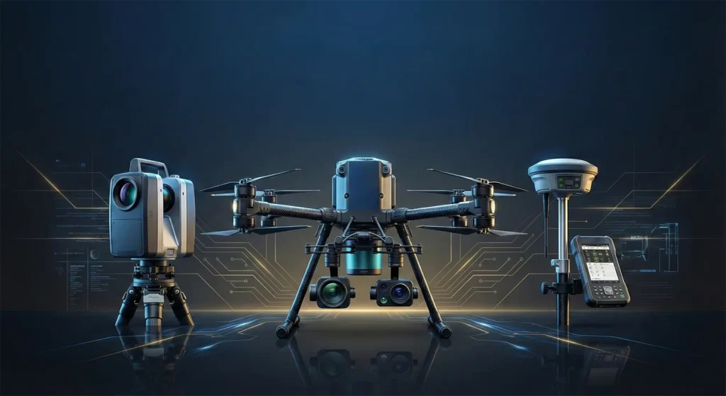
نقدم منظومة متطورة في المسح الجوي والتصويري باستخدام الطائرات بدون طيار والمنصات الجوية المأهولة تغطي جمع البيانات الجوية، والنمذجة ثلاثية الأبعاد، وإنتاج الخرائط الرقمية، والتحليل الزمني لرصد التغيرات. نوفر أدوات دقيقة لدعم التخطيط الحضري والاستدامة وإدارة الأصول.
نوفر حلولا متكاملة في مسح المرافق تشمل تحديد مواقع الشبكات، وتوصيفها، ونمذجتها بشكل ثنائي وثلاثي الأبعاد، وبناء قواعد بيانات مكانية داعمة لإدارة الأصول والتنسيق الهندسي. وتمكين الجهات من تقليل التعارضات وتحسين كفاءة التخطيط وتقليل المخاطر أثناء التنفيذ.
نقدم خدمات متقدمة في أنظمة الخرائط ثلاثية الأبعاد تعتمد على تقنيات التقاط الواقع، والمسح الليزري، والنمذجة الرقمية لإنتاج نماذج حضرية دقيقة تدعم التخطيط العمراني، وإدارة الأصول، ومشاريع المدن الذكية وفق أعلى المعايير.
نوفر منظومة متكاملة في المسح الليزري والنمذجة تشمل التقاط الواقع ثلاثي الأبعاد، ومعالجة السحب النقطية، وإنتاج النماذج الرقمية وربطها بمنصات BIM وGIS والتوائم الرقمية. نمكن الجهات من الانتقال من الواقع إلى النموذج الرقمي بدقة وموثوقية تدعم إدارة المشاريع، وتقليل المخاطر، وتعظيم كفاءة دورة حياة الأصول.
نعمل على تصميم وبناء أطر حوكمة البيانات الجيومكانية، وصياغة سياسات إنشاء وتحديث وإدارة البيانات لمختلف القطاعات، إلى جانب تطوير المعايير التشغيلية ونماذج إدارة الجودة، بما يُمكّن مشاريع التحول الرقمي الجيومكاني من تحقيق أعلى مستويات التكامل والتوافق بين الجهات ذات العلاقة.
في القطر نمتلك أحدث التقنيات المتقدمة والبرمجيات الإحترافية التي تضمن تحقيق أعلى معايير الدقة في النتائج، وتضمن مختلف الأنواع من المخرجات الإحترافية متعددة الإشكال لتوفير بيانات تضمن للعملاء سرعة إتخاذ قرارات موثوقة.
تساهم قدراتنا المتقدمة في مجالات المسح الأرضي، التقاط الواقع، النمذجة الجيومكانية الرقمية، وتحليل وتكامل البيانات المكانية من تلبية احتياجات القطاعات المختلفة بدقة تشغيلية عالية. تتكامل حلولنا لدعم التخطيط، والتنفيذ، وإدارة الأصول، وتمكين الاستدامة عبر مشاريع البنية التحتية والتنمية العمرانية وبناء المدن الذكية.
نستعرض مجموعة مختارة من المشاريع التي توظّف التقنيات الجيومكانية المتقدمة لمعالجة متطلبات تشغيلية معقّدة، بما يعكس نضج القدرة التنفيذية وجودة المخرجات ودعم اتخاذ القرار عبر مختلف البيئات والمشاريع.
فريقنا الهندسي جاهز لدراسة متطلبات مشروعك وتقديم أنسب الحلول المساحية والجيومكانية بأعلى معايير الكفاءة